The Airport Information Network has been developed
as a service to the aviation community to collaboratively
manage diversions, tarmac delays and field condition changes.
To change your airport from a small dot to a large one, click here for more details.
What's New: Click here to check out the newest features in this current release of AIN.
For additional information about this page, please click here.
FAA Diversions
FAA Diversions
No current diversions
Airport
Enroute
On Ground
BOS
4
2
JFK
1
Alerts- Only Airports
FCR Airports
ABC
ABC
Critical airport alert
ABC
ABC
FAA flight delay information
ABC
ABC
Advisory airport alert
ABC
No current airport alert or FAA flight delay info
Alaska Airlines
American Airlines
Delta Air Lines
FedEx
JetBlue Airways
United Airlines
Over 100 participating airports
Refresh:
Last Update:
none + none + none
Changing Your Airport's Dot Size
Alerts-Only Airports
PASSUR provides a free basic messaging service to any airport that
would like to participate in the Airport Information Network.
Airports are able to post alerts about conditions at their
facility that are viewable by the entire aviation community,
including all major airlines, airports, flight service
providers, FBOs, and corporate flight departments. "Alerts Only"
airports are indicated with a small dot that changes to a lozenge
when an alert is posted.
FCR Airports
PASSUR offers an additional level of value to airports by consolidating
all NOTAMS and non-NOTAM information on an individual and customized
airport page. This is a paid level of service and participating airports
are indicated with a large dot.
Key features of this PASSUR solution include:
•
A single, web-based point of information management
•
Automatic integration and interfacing with FAA Flight Services/Digital NOTAMS
•
Customized information boxes, construction, tenant advisories, etc.
•
Automated emails and text messages on condition changes
•
Automated update of logs for historic reports
•
Real-time communication through online chat
To get more detail, call 203-622-4086 or email sales@passur.com.
How the page works
The Airport Information Network is a free service for the aviation community.
It provides airports, airlines, FBOs and other service providers a single
source to view and share critical real-time information and fulfills the
industry's need for:
•
Identification of diverted flights for both airports and airlines
•
Real-time communication of airport status
•
Easier identification and management of tarmac-delayed aircraft
You can access the web page through various Internet-equipped devices: laptops,
tablets, smart phones, etc. Airports can post their status and/or an alert message
in real time. Diversion information "en route and on ground" is auto-populated
and viewable nationwide.
Without logging into the site you may:
•
View the FAA Flight Delay Information and access a link to the FAA OIS page
•
Navigate to Airports that have a full airport field condition page
When logged in you will have access to the above information as well as:
•
Read-only version of each of the full airport field condition report pages without the need for further login
•
Additional real-time operational performance metrics for the full PASSUR Field Condition Report airports only, including:
º
# of Diversions From
º
# of Diversions To
º
Current arrival rate
º
Current departure rate
º
Current # of aircraft holding for that airport
º
Projected imbalance between GDP and historical performance
•
Airport Messaging
•
FAA Diversion Information
Note: Users who currently have an active user name and password for
any other PASSUR Web-based solution (for example, PASSUR OPSnet/FCR,
Portal, PASSUR Integrated Traffic Management, Tarmac Delay Management,
etc.) can use the same user name/password combination to access this site.
Full access to this site is limited to aviation professionals.
There have been several updates to the Airport Information Network.
1. Universal Access to all Airport Field Condition Reports (PASSUR FCR)
3.
AIN members have to only login once to the AIN main page to have access to the PASSUR FCR pages of all airports subscribing to that service (the bigger dots on the map) in a "read-only" version (updated continuously to reflect airport updates). Click on "View PASSUR FCR Page".
AIN members who have separate logins to any of the FCR airports can still login to those pages directly, as they always have, by clicking on "Open PASSUR FCR Page".
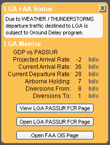
2. New airport performance metrics for PASSUR FCR airports
3.
For all PASSUR FCR-subscribing airports, users will now see a new group of valuable airport and system performance data driven by the PASSUR surveillance network and databases. These include:
•
GDP vs PASSUR Projected Arrival Rate: Displayed whenever the planned GDP rate differs by ±2 arrivals/hr or more from PASSUR's historically calculated arrival rate for the next hour (based on forecast weather conditions).
•
Current Arrival Rate: actual observed arrivals over the past 15 minutes, expressed as an hourly rate.
•
Current Departure Rate: actual observed departures over the past 15 minutes, expressed as an hourly rate.
•
Airborne Holding: number of aircraft bound for the airport that are currently holding.
•
Diversions From: cumulative number of aircraft diverted away from the airport, starting from the current time of day up to the last five hours.
•
Diversions To: cumulative number of aircraft diverted to the airport, starting from the current time of day up to the last five hours.
3. New airport icons and color key
3.
The revised legend reflects changes designed to make it easier for users to distinguish the different levels of airport status.
4. Instant access to the IATA Tactical Operations Portal (ITOP)
Managed by IATA at the FAA Air Traffic Control System Command Center (ATCSCC). For IATA members (separate login required on that page).
5. Make yourself heard
Email us directly from AIN with suggestions for upcoming releases.
The diversions in this list are derived from flight plan changes,
from the current time of day up to the last five hours.
Diversion counts that appear as an overlay for the large-dot PASSUR
FCR airports on the map to the right are derived from the PASSUR
national fused surveillance network and software. The PASSUR list
is frequently more comprehensive, so the diversion numbers in this
list and on the airport dot may not match. This list will be upgraded
in a coming release.